ਇੰਗਲੈਂਡ: ਰੀਵਿਜ਼ਨਾਂ ਵਿਚ ਫ਼ਰਕ
ਸਮੱਗਰੀ ਮਿਟਾਈ ਸਮੱਗਰੀ ਜੋੜੀ
No edit summary |
Satdeepbot (ਗੱਲ-ਬਾਤ | ਯੋਗਦਾਨ) |
||
| ਲਾਈਨ 75: | ਲਾਈਨ 75: | ||
}} |
}} |
||
'''ਇੰਗਲੈਂਡ''' [[ਯੂਨਾਈਟਿਡ ਕਿੰਗਡਮ]] ਦਾ ਇੱਕ ਦੇਸ਼ ਹੈ। ਇਹ ਉੱਤਰ ਵੱਲ [[ਸਕਾਟਲੈਂਡ]] ਨਾਲ ਅਤੇ ਪੱਛਮ ਵਿੱਚ [[ਵੇਲਜ਼]] ਨਾਲ ਜ਼ਮੀਨੀ ਹੱਦਾਂ |
'''ਇੰਗਲੈਂਡ''' [[ਯੂਨਾਈਟਿਡ ਕਿੰਗਡਮ]] ਦਾ ਇੱਕ ਦੇਸ਼ ਹੈ। ਇਹ ਉੱਤਰ ਵੱਲ [[ਸਕਾਟਲੈਂਡ]] ਨਾਲ ਅਤੇ ਪੱਛਮ ਵਿੱਚ [[ਵੇਲਜ਼]] ਨਾਲ ਜ਼ਮੀਨੀ ਹੱਦਾਂ ਸਾਂਝਾ ਕਰਦਾ ਹੈ।<ref>{{cite web|title=The Countries of the UK|url=http://www.statistics.gov.uk/geography/uk_countries.asp|publisher=statistics.gov.uk|accessdate=1 February 2009|author=Office for National Statistics|authorlink=Office for National Statistics|archiveurl=http://web.archive.org/web/20081220225201/http://www.statistics.gov.uk/geography/uk_countries.asp <!--Added by H3llBot-->|archivedate=20 December 2008}}</ref><ref>{{cite web|title=Countries within a country|url=http://www.number-10.gov.uk/output/Page823.asp|archiveurl=http://web.archive.org/web/20080209003312/http://www.number-10.gov.uk/output/Page823.asp|archivedate=9 February 2008|publisher=number-10.gov.uk|accessdate=1 February 2009|authorlink=Prime Minister of the United Kingdom}}</ref><ref>{{cite web|title= Changes in the list of subdivision names and code elements (Page 11)|url=http://www.iso.org/iso/newsletter_i-9.pdf|format=PDF|publisher=[[International Organization for Standardization]]|accessdate=1 February 2009}}</ref> [[ਆਇਰਲੈਂਡੀ ਸਮੁੰਦਰ]] ਇੰਗਲੈਂਡ ਤੋਂ ਉੱਤਰ ਪੱਛਮ ਵੱਲ ਅਤੇ ਸੇਲਟਿਕ ਸਮੁੰਦਰ ਦੱਖਣ-ਪੱਛਮ ਵੱਲ ਪੈਂਦਾ ਹੈ। ਇੰਗਲੈਂਡ ਨੂੰ ਉੱਤਰ ਸਾਗਰ ਤੋਂ ਪੂਰਬ ਵਿੱਚ ਅਤੇ ਮਹਾਂਦੀਪ ਯੂਰਪ ਤੋਂ ਦੱਖਣ ਵੱਲ ਇੰਗਲਿਸ਼ ਚੈਨਲ ਰਾਹੀਂ ਵੱਖ ਕੀਤਾ ਗਿਆ ਹੈ। ਇਹ ਦੇਸ਼ ਗ੍ਰੇਟ ਬ੍ਰਿਟੇਨ ਦੇ ਪੰਜ-ਅੱਠਵਿਆਂ ਨੂੰ ਸ਼ਾਮਲ ਕਰਦਾ ਹੈ, ਜੋ ਉੱਤਰੀ ਅਟਲਾਂਟਿਕ ਵਿੱਚ ਸਥਿਤ ਹੈ ਅਤੇ ਇਸ ਵਿਚ 100 ਤੋਂ ਜ਼ਿਆਦਾ ਛੋਟੇ ਟਾਪੂ ਸ਼ਾਮਲ ਹਨ ਜਿਵੇਂ ਕਿ ਆਇਲਸ ਆਫ ਸਕਾਈਲੀ ਅਤੇ [[ਆਇਲ ਆਫ਼ ਵਾਟ|ਆਇਲ ਆਫ ਵਾਈਟ]]। |
||
==ਹਵਾਲੇ== |
==ਹਵਾਲੇ== |
||
06:52, 4 ਮਈ 2019 ਦਾ ਦੁਹਰਾਅ
ਇੰਗਲੈਂਡ | |
|---|---|
 ਝੰਡਾ | |
| ਐਨਥਮ: Various Predominantly "God Save the Queen" | |
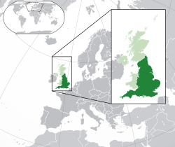
 Location of England (dark green) – in Europe (green & dark grey) | |
| ਰਾਜਧਾਨੀ ਅਤੇ ਸਭ ਤੋਂ ਵੱਡਾ ਸ਼ਹਿਰ | ਲੰਡਨ |
| National language | ਅੰਗਰੇਜ਼ੀ |
Regional languages | Cornish |
| ਨਸਲੀ ਸਮੂਹ (2011) | |
| ਵਸਨੀਕੀ ਨਾਮ | English |
| Sovereign state | ਸੰਯੁਕਤ ਬਾਦਸ਼ਾਹੀ |
| History | |
| 5th–6th century | |
| 10th century | |
| 1 May 1707 | |
| ਖੇਤਰ | |
• ਕੁੱਲ | 130,395 km2 (50,346 sq mi) |
| ਆਬਾਦੀ | |
• 2011 ਜਨਗਣਨਾ | 53,012,456 |
• ਘਣਤਾ | 407/km2 (1,054.1/sq mi) |
| ਜੀਡੀਪੀ (ਨਾਮਾਤਰ) | 2009 ਅਨੁਮਾਨ |
• ਕੁੱਲ | $2.68 trillion |
• ਪ੍ਰਤੀ ਵਿਅਕਤੀ | $50,566 |
| ਮੁਦਰਾ | Pound sterling (GBP) |
| ਸਮਾਂ ਖੇਤਰ | GMT (UTC) |
• ਗਰਮੀਆਂ (DST) | UTC+1 (BST) |
| ਮਿਤੀ ਫਾਰਮੈਟ | dd/mm/yyyy (AD) |
| ਡਰਾਈਵਿੰਗ ਸਾਈਡ | left |
| ਕਾਲਿੰਗ ਕੋਡ | +44 |
ਇੰਗਲੈਂਡ ਯੂਨਾਈਟਿਡ ਕਿੰਗਡਮ ਦਾ ਇੱਕ ਦੇਸ਼ ਹੈ। ਇਹ ਉੱਤਰ ਵੱਲ ਸਕਾਟਲੈਂਡ ਨਾਲ ਅਤੇ ਪੱਛਮ ਵਿੱਚ ਵੇਲਜ਼ ਨਾਲ ਜ਼ਮੀਨੀ ਹੱਦਾਂ ਸਾਂਝਾ ਕਰਦਾ ਹੈ।[2][3][4] ਆਇਰਲੈਂਡੀ ਸਮੁੰਦਰ ਇੰਗਲੈਂਡ ਤੋਂ ਉੱਤਰ ਪੱਛਮ ਵੱਲ ਅਤੇ ਸੇਲਟਿਕ ਸਮੁੰਦਰ ਦੱਖਣ-ਪੱਛਮ ਵੱਲ ਪੈਂਦਾ ਹੈ। ਇੰਗਲੈਂਡ ਨੂੰ ਉੱਤਰ ਸਾਗਰ ਤੋਂ ਪੂਰਬ ਵਿੱਚ ਅਤੇ ਮਹਾਂਦੀਪ ਯੂਰਪ ਤੋਂ ਦੱਖਣ ਵੱਲ ਇੰਗਲਿਸ਼ ਚੈਨਲ ਰਾਹੀਂ ਵੱਖ ਕੀਤਾ ਗਿਆ ਹੈ। ਇਹ ਦੇਸ਼ ਗ੍ਰੇਟ ਬ੍ਰਿਟੇਨ ਦੇ ਪੰਜ-ਅੱਠਵਿਆਂ ਨੂੰ ਸ਼ਾਮਲ ਕਰਦਾ ਹੈ, ਜੋ ਉੱਤਰੀ ਅਟਲਾਂਟਿਕ ਵਿੱਚ ਸਥਿਤ ਹੈ ਅਤੇ ਇਸ ਵਿਚ 100 ਤੋਂ ਜ਼ਿਆਦਾ ਛੋਟੇ ਟਾਪੂ ਸ਼ਾਮਲ ਹਨ ਜਿਵੇਂ ਕਿ ਆਇਲਸ ਆਫ ਸਕਾਈਲੀ ਅਤੇ ਆਇਲ ਆਫ ਵਾਈਟ।
ਹਵਾਲੇ
- ↑ "2011 Census: KS201EW Ethnic group: local authorities in England and Wales". Office for National Statistics. Retrieved 18 April 2014.
- ↑ Office for National Statistics. "The Countries of the UK". statistics.gov.uk. Archived from the original on 20 December 2008. Retrieved 1 February 2009.
- ↑ "Countries within a country". number-10.gov.uk. Archived from the original on 9 February 2008. Retrieved 1 February 2009.
- ↑ "Changes in the list of subdivision names and code elements (Page 11)" (PDF). International Organization for Standardization. Retrieved 1 February 2009.
| ਇਹ ਲੇਖ ਅਧਾਰ ਹੈ। ਤੁਸੀਂ ਇਸਨੂੰ ਵਧਾਕੇ ਵਿਕੀਪੀਡੀਆ ਦੀ ਮੱਦਦ ਕਰ ਸਕਦੇ ਹੋ। |
